
Gulf Tropical Storm Likely Threat To Florida, Southeast Late This Week…
iNFO Vi 
 • Bookmarks: 2

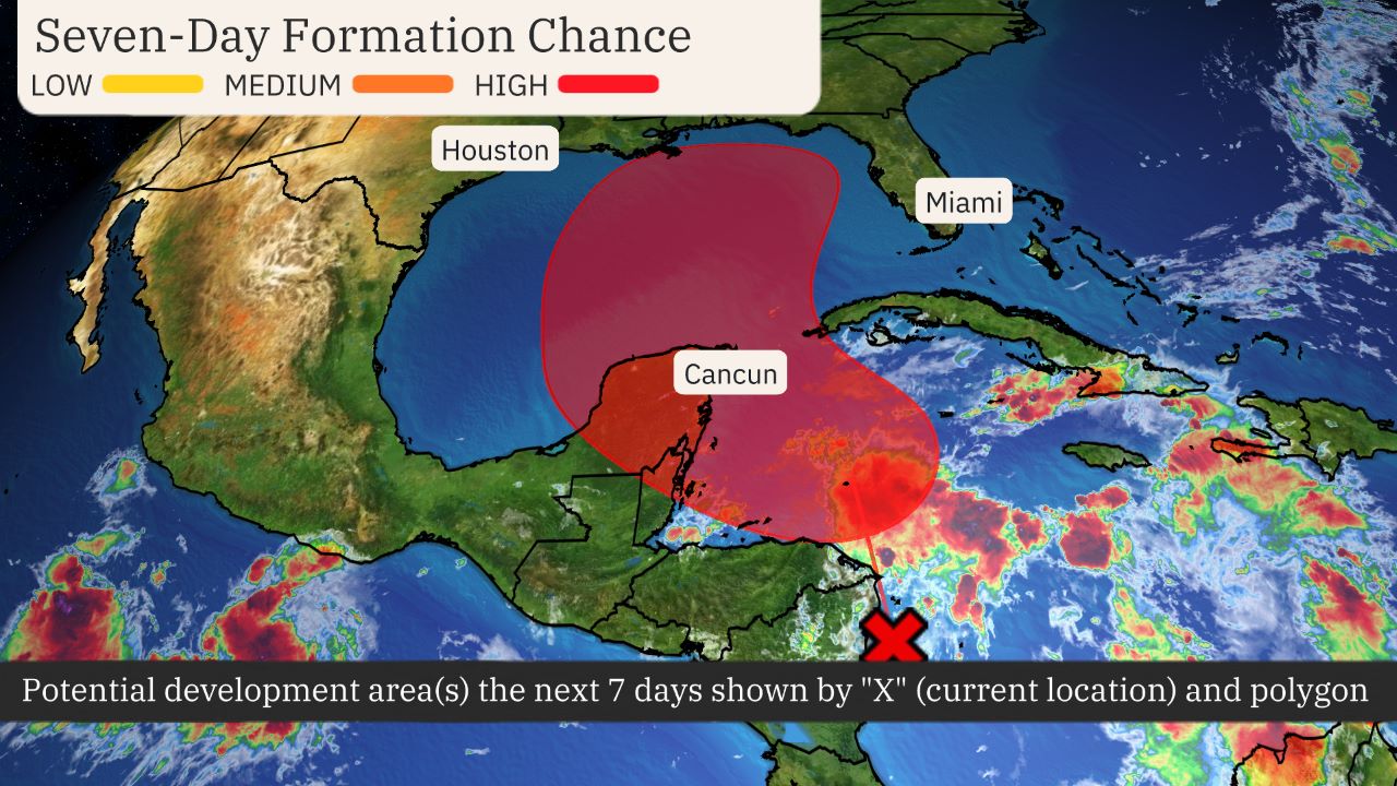
- An area in the northwest Caribbean is being watched.
- A tropical storm will likely develop in the next few days and enter the Gulf of Mexico.
- Details remain uncertain, but the U.S. Gulf Coast from Florida to Louisiana should monitor the forecast closely.
- Most forecast models suggest a landfall in Florida or the northern Gulf Coast Thursday.
- Impacts could linger in parts of the South or Southeast coast into Friday.
A tropical storm is expected to form in the northwest Caribbean Sea or southern Gulf of Mexico and may become a hurricane before it heads toward either Florida or the northern Gulf Coast late this week.
Interests along the U.S. Gulf Coast from Louisiana to Florida should continue to monitor the situation closely and stay updated on how the forecast unfolds in the days ahead.
The area to watch: An area of low pressure is expected to form soon over the western Caribbean Sea. Thunderstorms are already becoming more numerous in this area.
The National Hurricane Center has outlined an area in the western Caribbean Sea and southern Gulf of Mexico for the likely formation of a tropical storm. The NHC has also scheduled its first Hurricane Hunter mission to the western Caribbean Sea for Monday afternoon.
Here is when a storm could form and where it could track:
- Monday-Tuesday: The latest computer forecast models suggest a tropical depression or storm could form as soon as late Monday or Tuesday. By Tuesday, it could near Cancún and Cozumel or western Cuba. Locally heavy rain is possible in those areas. The next storm name is Helene.
- Wednesday: We expect this system to enter the southern Gulf of Mexico, likely as a tropical storm.
- Thursday: We expect storm be drawn generally northward in the Gulf of Mexico by steering winds around high pressure off the Southeast coast and low pressure over the south-central U.S. As usual, forecast models differ somewhat this far out. But in general, that could bring the center of this system to the Gulf Coast somewhere between Florida and Louisiana either Thursday or Thursday night, possibly as a hurricane.
- Friday: This system is most likely to continue inland with weakening winds, but locally heavy rain over the Southeast.

How strong could it become: It’s increasingly possible this system could become a hurricane in the Gulf. Oceanic heat content is one favorable ingredient for intensification, and the map below shows there is plenty of deep, warm water in the northwest Caribbean and parts of the Gulf of Mexico.
But there are other factors that also matter, like whether or not the upper-level wind pattern is favorable for significant strengthening. It’s also unknown if any nearby dry air could hinder intensification.
Interests along the U.S. Gulf Coast should monitor the situation closely while also making sure hurricane preparedness plans are in place. Check back with us at weather.com and The Weather Channel app for updates through the weekend and beyond as we fill in more details on what to expect.

Rainfall potential: While it’s far too soon for specifics on other impacts – including storm surge and winds – we expect this future storm to produce heavy rainfall generally along and to the east of its track.
The heaviest rain is expected Thursday into Friday in parts of the Southeast, but some bands of heavy rain could arrive as early as Wednesday. This rain could lead to flash flooding, especially where it combines with storm surge and over higher terrain.

Rainfall Outlook
(While not all of the rainfall shown above is from this tropical system, this should be interpreted as a broad outlook of where the heaviest rain may fall. Higher amounts may occur where bands or clusters of thunderstorms stall for over a period of a few hours.)

 Share
Share Print
Print